
Do you know what district you work in?
New color-coded district signage is now being installed as part of the campus’s year-long wayfinding project.
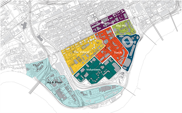
The first district sign—designating the River District—can now be seen at the corner of Neyland Drive and Joan Cronan Way, formerly Leinard Lane. The sign will soon get a strip of the color Summitt, a pale blue-green that signifies water.
The wayfinding framework divides the campus into seven color-coded districts to make it easier to give directions in a broader context of the campus layout.
 The names were developed based on a combination of geography, function, and branding. For example, “the Village” is a reflection of the residence halls and student life functions of that district and “Torch” designates the academic core of campus.
The districts and their colors are the Village (Sunsphere, golden yellow), the Hill (Switchgrass, medium green), Neyland (Globe, medium blue), Cumberland (Regalia, purple) Volunteer (Valley, deep blue-green) Torch (Torch, bright red-orange), and River (Summitt). View the district map.
Workers are now installing parking lot signage within the districts that display the district color. Facilities Services began the project last August by first installing the exterior building signage. The new system helps align campus signage with UT Knoxville’s brand standards.
UT’s online tools, like the campus map, are also being improved so that people coming from off-campus locations can get more precise directions, along with information about the best place to park, from their mobile device.
The wayfinding system supports UT’s master plan goals for becoming a more pedestrian- and bicycle-friendly campus and promotes transit as the best way to move through the center of campus.
For more information, contact Ted Murphy at 865-974-2178.